Exploration Project Screening
Rapid technical review of available project data to assess mineral potential, technical risks, data gaps and recommended next exploration steps.
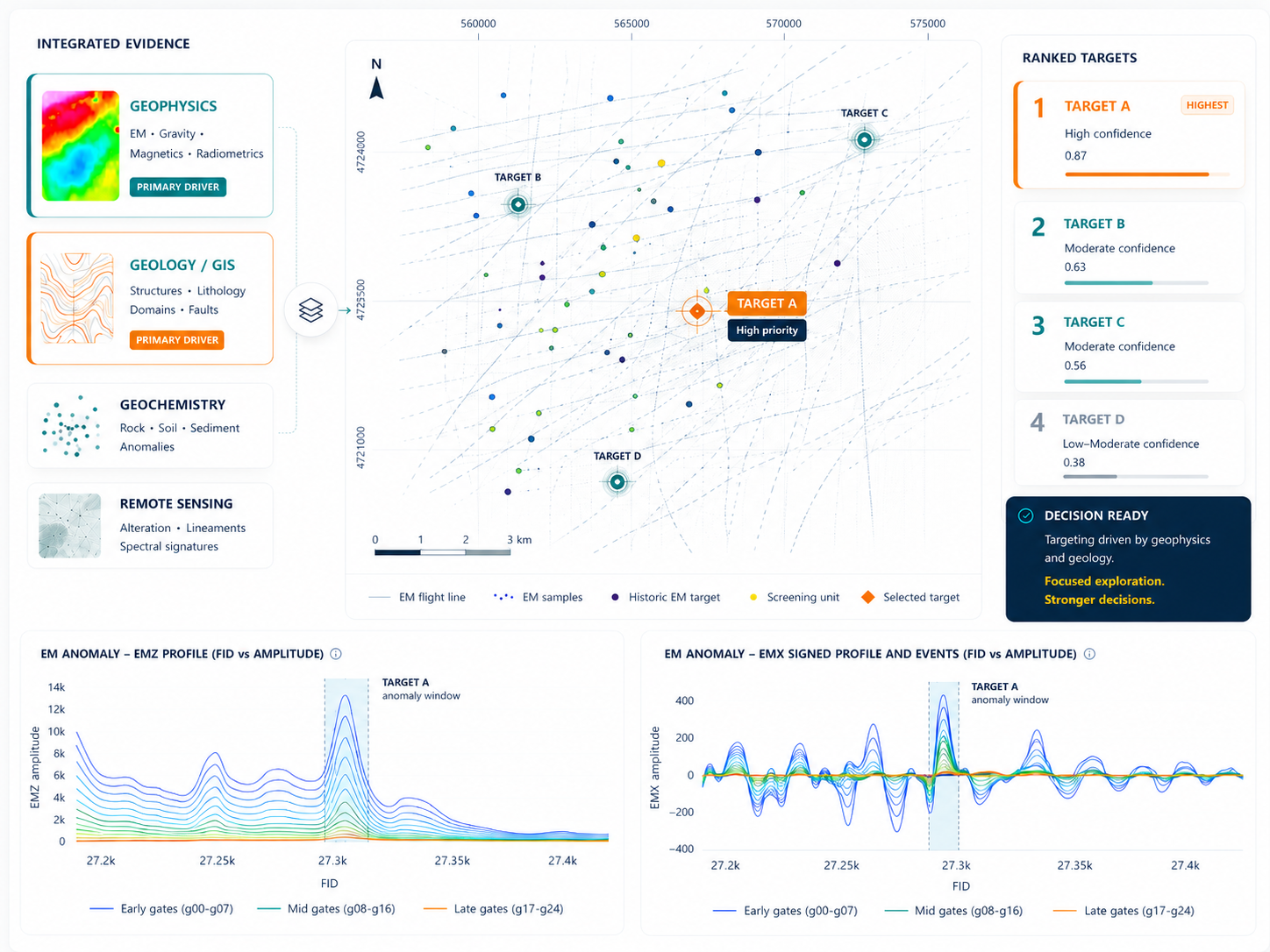
Mineral exploration consulting
Integrated geoscience consulting for mineral exploration teams that need clearer targets, better-ranked opportunities and decision-ready technical outputs.
Based in Madrid, operating internationally
Oryndra Geoscience is a boutique geoscience consulting initiative based in Spain and focused on mineral exploration.
We bring together applied geophysics, geological interpretation, GIS, remote sensing and technical automation to help exploration teams turn complex datasets into clear targets, technical insights and decision-ready outputs.
Our work is designed for early-stage project reviews, integrated target generation, geophysical interpretation, satellite-based exploration mapping and practical GIS/data workflows.
Services
Modular support for project reviews, targeting workflows, geophysical interpretation, satellite mapping and practical GIS/data automation.
Rapid technical review of available project data to assess mineral potential, technical risks, data gaps and recommended next exploration steps.
Integration of geological, structural, geochemical, geophysical, satellite, GIS and drillhole data to define and rank exploration targets.
QA/QC, processing review, enhancement, anomaly mapping, structural/domain interpretation and 2D/3D inversion where applicable.
Remote sensing analysis for alteration mapping, lithological discrimination, surface feature interpretation and GIS-ready exploration outputs.
GIS database organization, QGIS workflows, Python scripts, automated map generation and practical tools to reduce repetitive technical work.
Focused support for teams that need practical upskilling in GIS, geophysical interpretation, remote sensing or repeatable technical workflows.
Approach
Each engagement is shaped around the project stage, available datasets, exploration question and decision that the technical work needs to support.
Assess data coverage, quality, coordinate systems, formats, gaps and usable history.
Combine geological, structural, geochemical, geophysical, satellite and GIS layers.
Convert technical patterns into mapped opportunities, priorities and next-step logic.
Provide clear maps, tables, summaries, workflows and recommendations for action.
Outputs
Prioritized opportunities with supporting criteria, confidence and follow-up rationale.
Clean spatial layers, map products and organized datasets ready for exploration teams.
Reviewed, enhanced and interpreted geophysical products to support target definition.
Alteration, lithological and surface interpretation layers prepared for GIS use.
Concise documentation of methods, observations, uncertainty and recommended next steps.
Reusable Python, QGIS or notebook-based workflows that reduce repetitive technical work.
Contact
Share the project area, commodity, available datasets and the decision you need to make. We can then define a focused technical review or a broader targeting workflow.